Wednesday, April 6, 2011

Taba (egypttoursandexcursions.com)


Taba
Taba, in the eastern Sinai peninsula of Egypt, marks the location of the southern border crossing between Egypt and Israel, servicing travellers coming into Egypt and Sinai via Eilat. The town has grown up around the border crossing and offers basic amenities for travellers - these will no doubt be greatly enhanced when a new "Taba Heights" development gathers pace. Taba is a relatively minor centre for Red Sea diving.
Taba was on the Egyptian side of the armistice line agreed to in 1949, and returned to Egypt when Israel withdrew from Sinai in 1957. However, when Egypt and Israel were negotiating the exact position of the border in preparation for the peace treaty, Israel claimed that Taba had been on the Ottoman side of a border agreed between the Ottomans and British Egypt in 1906 and had therefore been in error in its two previous agreements.
After a long dispute, the issue was submitted to an international commission composed of one Israeli, one Egyptian, and three outsiders. In 1988, the commission ruled in Egypt's favor and Israel returned Taba to Egypt later that year.
As part of this subsequent agreement, Israeli travelers are permitted to visit Taba visa-free for up to 48 hours, making Taba a popular tourist destination.
Attractions and Excursions in Taba
Island of Pharaoh
Pharaoh's Island : One of Taba's main attractions, Pharaoh's Island, is simply breathtaking. The small island, surrounded by outstanding blue and turquoise waters of the Red Sea, was once a Phoenician port, later occupied by Crusaders and then taken under control by Sultan Salah El Din. The island and the castle remain intact. The reef around the island is popular with snorkellers and divers alike.

Pharaoh's Island, also called Coral Island or Geziret Faroun, lies eight kilometers south of Taba and 250 meters off the coast.

The Phoenicians were the first to make use of this island's fine natural harbor during the 10th century BC to foster trade with Egypt. Much later the small rocky island came under Byzantine control.

Early in the 12th century the Crusaders built a fortress there to protect pilgrims traveling between Jerusalem and the Monastery of St Katherine and to boost Arab trade. Sultan Salah El Din (Saladin) evicted the Crusaders from the island and significantly strengthened the fortress later in the 12th century. The Mamelukes and Ottomans probably further fortified it when they became the dominant force of the region.

Today you can follow in the footsteps of the legendary Lawrence of Arabia and explore the fully renovated fortress of medieval character with its towers, arched doorways, sleeping quarters, baths and kitchens

Mount Sinai,just south of the Monastery of St Katherine, is of great religious importance to Jews, Christians and Muslims. According to the Old Testament this is where Moses received the Ten Commandments.

Throughout the centuries the mountain has drawn thousands of pilgrims from all over the world. You can ascend to the summit (2285 m, 7497 ft) to experience the ultimate spiritual elevation; either by climbing some 4000 steps built by monks or by following an easier but longer path. Both lead to an open area known as Elija's Basin where you walk up the remaining 750 steps to the top.

At the summit you will find the Chapel of the Holy Trinity that was built in 1934 on the site of a much earlier chapel built in 363 AD. The climb takes about three hours but the view from the top is truly breathtaking, especially at sunrise.
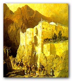
The Monastery of St. Katherine lies at the foot of Gebel Musa, or Moses Mount , in the heart of the South Sinai. In 330 AD the mother of Emperor Constantine, Empress Helena, ordered the construction of a small church by Moses' Burning Bush. It was called the Church of the Transfiguration. The fortified monastery we see today was built around this church during the reign of Emperor Justinian (527-565 AD).
In the 11th century the monastery was dedicated to St. Katherine of Alexandria, who had died in 310 AD. Her remains, reportedly found by monks on a mountain peak next to Mt Sinai, are buried in the monastery's Basilica.
Fronted by gardens and cypress trees, the monastery is owned and run by the Greek Orthodox Church. Its rich library houses the world's second largest collection of illuminated manuscripts after the Vatican. You can see the Burning Bush and a large number of antique works of art: invaluable icons, beautifully carved doors, exquisite wall paintings and other fine religious ornaments.
The Museum at St Katherine Monastery

St. Catherine Monastery    
In February 2002, within the monastery's towering walls, one of the world's finest and most unique collections of Christian artifacts has been made more accessible to the public. A small yet extraordinary nine-room museum, referred to as "The Sacred Sacristy", was opened to display masterpieces of the highest artistic value.
Among the tastefully displayed exhibits are exquisite 6th century Byzantine icons, delicate 9th century manuscripts written in Syriac, rare Slavonic prayer books, including splendid objects of silver, gold, ivory and precious stones. Perhaps the most valued items on exhibit, presented in a special glass case, are pages from the Codex Sinaiticus, a 4th century version of the Bible that now rests in the British Museum.
Now you can see the Monastery's coveted collection, while listening to gentle Byzantine hymns in an atmosphere of splendor and reverence. The museum is open from 9 to 12 am everyday except Fridays, Sundays and religious holidays.

One of the jewels of Sinai, Ein Kid is a palm-filled oasis at the end of a pastel colored path. Promising shade and tranquility for every visitor, Ein Kid is the perfect remedy for the stress of urban life.

The walk from Wadi Kid to Ein Kid is stunning as you spot the water flowing down from the oasis. The path is flanked by awesome granite boulders hovering, as you ascend into the oasis. You will feel so small in the shadows of these stupendous creations.

When you set your eyes on the oasis, you will be amazed by the contrast of colors created by the desert landscape and the lush trees. Complete with date palms, acacias, and fruit bearing trees, Ein Kid is the ultimate place for an afternoon picnic and a hike. You can organize a day trip or camping trip from Sharm el Sheikh or Dahab.

the blue desert
The most amazing thing about the Blue Desert isn't the blue paint on the rocks, it is the wadi itself - against the backdrop of the legendary blue Sinai sky. Massive granite sculptures and golden boulders cover the desert floor along with beautiful pink flowers dotting the plains. The Blue Desert is a great place for climbing, taking pictures or just getting away from it all.

In 1980, Belgian artist Jean Verame came to Sinai to paint a line of peace. With the permission of Anwar Sadat and a grant of ten tons of paint from the UN, the artist managed to paint four miles of Sinai. One year later, a stretch between Dahab and St Katherine was blue; hence, the name became the Blue Desert.

Located between Dahab and St Katherine, you can easily see this site in one day. However, it is a great place for camping.

Coloured Canyon Coloured Canyon
One of the natural wonders of Sinai, the Coloured Canyon is awe-inspiring. Take a walk in between dramatic sandstone canyon walls streaked with melting yellows, purples, reds, magentas and gold. In certain places the canyon walls reach up to 40 meters. You feel as if you are enclosed in a spectacular colouring book.

Formed by the natural elements over centuries, the walls of Coloured Canyon cascade with colours as a result of ferrous oxide and manganese. Consequently, a natural maze has been formed that is excellent for exploring and taking photographs. A haven of tranquility, Coloured Canyon promises its visitors peaceful moments and quiet.

To ensure your safety, in some areas of the Coloured Canyon you will need to be reasonably fit to investigate. Day trips to the Coloured Canyon can be arranged from Dahab, Nuweiba, or Taba.

Abu Galum Protected Area
Abu Galum Protected Area, along the Gulf of Aqaba between Dahab and Nuweiba, is a 500 km2 natural wonderland. Shell speckled gravel beaches run parallel most of the way to the splendid coral reefs below, unless rudely interrupted by plunging mountainsides. Close examination of the beaches will expose masses of Nerita splendens, a tiny snail whose decorative shell blends seamlessly into the pebble mosaic.

Inland into the park, deep wadis interlace with massive granite mountains that are intermittently cut by dark dolerite dykes. Out of a total 167 species recently recorded in this environmentally unique region, as many as 44 plant species are endemic. Mammals seem to like this plant diversity. Nubian ibex, hyrax, red fox and striped hyena thrive here, as well as a variety of lizards and snakes, including the black cobra, the horned viper and Burton's carpet viper.

Ein Khadra
Tucked away between yellowish sandstone cliffs not far from the road linking St Katherine with Nuweiba and Dahab is one of Sinai's most scenic oases. Its Arabic name Ein Khadra (Green Oasis) perfectly describes this attractive locale where gushing fresh water springs nourish date palm gardens in the seemingly barren desert.
When approaching from the south you'll be greeted by a splendid panorama view of the small oasis glaring brilliantly in the distance below. If you enjoy observing dramatic geological landscape, a walk through the White Canyon that flows into Ein Khadra from the southeast is surely worth the effort.
More than just a pretty spot, Ein Khadra is also historically significant. It acted as an important stopover for pilgrims traveling the St Katherine-Jerusalem route. Ancient writings and drawings on the nearby Rock of Inscriptions testify that Nabateans, Greeks, Romans, Byzantines and Christians of the Crusader period passed through here. Have your camera ready!
Although not as dramatic as Sharm el Sheikh's walls or Marsa Alam's offshore reefs, the Taba coast offers some very rare marine life in an uncrowded environment. Typical to the area, for example, is a rare species of frogfish, and many species of seahorses, hardly found anywhere else in the Red Sea, making a diving holiday in Taba a unique one.
Most of the dive sites in Taba are situated along the Red Sea coast, in the fringing reefs which adorn the Taba shoreline. They are mainly reachable by boat, but some have shore access from the hotel, and others and can be reached by car or jeep. Local dive boats leave every day for day or half-day diving excursions. The Taba dive sites are, in general, also easily accessible to snorkellers.
The Taba marine area is protected, as many other areas in Egypt, and diving centres here operate under environmental-friendly procedures. This year, a group of local investors have sponsored a mooring buoy project for the diving boats in the region, installing a total of 16 buoys in the most frequently visited dive sites
Taba Diving Services
diving in redsea
Most resorts in Taba have reliable and well-organized diving centres, which offer all sorts of scuba diving services, from entry-level courses to professional courses, introductory dives and diving packages, with one, two or more dives per day, for those who are certified. Some diving centres are also geared up to cater to technical divers. The area seems to be ideal to try out or practice with rebreathers.

For the non-licensed diving enthusiasts, most centres offer free of charge pool intro's, where visitors can experience the thrill of scuba diving on a one-to-one basis with a diving instructor in the hotel's swimming pool. The Taba diving centres also offer experience programmes, where the visitor can try actual dives in the sea straight away, under the strict supervision of a diving professional.
Taba, with its generally calm weather conditions and lack of currents, is an ideal location of the Red Sea Riviera to learn to dive, and most diving centers offer the full range of beginners' courses. Even kids from 8 years on can enroll in children-dedicated scuba diving activities, such as the popular bubble-maker course, where kids learn to be familiar with water and scuba diving and have fun swimming around in a confined water area.

www.egypttoursandexcursions.com                         http://ww.egypttoursandexcursions.com

for more info please follow us at
http://opitravel.net/
http://egypttoursandexcursions.com
http://sharmbestexcursions.com
http://hurghadabestexcursions.com
http://egypt-tourguides.com
http://sharmexcursions.net
http://sharmexcursion-tours.com
http://shoreexcursions-trips.com
 

Sharm El-Sheikh (sharmbestexcursions.com)


Sharm El-Sheikh
With its unique location in the Sinai Peninsula of Egypt, it is considered the strategic passageway, the meeting point between Asia and Africa, and the cradle of great civilizations.
It is no wonder that the stories of heavenly religions that dawned on humanity can be eloquently narrated by the soil of Sinai.
With its diverse features of environment that combine together history, tourism, industry and agriculture, it has become a main attraction for tourists, travelers and businessmen.
Sharm El-Sheikh, the biggest and most important city of Sinai, lies at the southern flank of the Peninsula where the two gulfs of Aqaba and Suez meet with the Red Sea.
sharm
Sharm El-Sheikh, apart from its military strategic position, was considered for more than 25 years an isolated part of Egypt. Only after the liberation war and Egypt's victory in 1973, and the ensuing peace agreement, the wonderful city of Sharm El-Sheikh emerged as a promising resort laden with many prospective potentials of prosperity. Since then a new era emerged in the history of Sinai and its largest city.
The Land of Peace Relaxing after a swim Sharm El Sheikh
The city of Sharm El-Sheikh is always referred to as the "Land of Peace" as many political, scientific and tourist conferences and meetings were held over its land.
President Mubarak hosted numerous key figures and held many conferences with the aim of promoting world peace at large. Among these conferences are:
1- The 1996 Peace Making Summit that was attended by many Arab and foreign Heads of State.
2- The G-15 Summit was held for the first time in Egypt in 1998 in Sharm El Sheikh .This Summit is held in rotation only in one of the group States.
3- Concluding Wye River Agreement between the Palestinians represented by their leader Yasser Arafat and Israel represented by the then Prime Minister Barak in September 1999. King Abdullah of Jordan, President Mubarak and US Secretary of State Albright also attended the meeting.
4- Sharm El-Sheikh trilateral Summit, which was attended by President Mubarak, Arafat and Barak aiming at boosting the peace process prior to the Palestinian-Israeli meeting in Camp David.
5- President Mubarak and Crown Prince of Saudi Arabia Prince Abdullah summit met in Sharm El-Sheikh to review Arab situation, peace process and bilateral cooperation.

Diving at Sharm El Sheikh
6- The trilateral summit that gathered President Mubarak, Crown Prince of Saudi Arabia Prince Abdullah and Syrian President Bashar Al Assad to discuss the ongoing peace process in the Middle East with special emphasis on the Syrian-Palestinian tracks of negotiations.
7- President Mubarak and Al Assad summit in 1998 to review the bilateral relations and the latest developments on the Syrian-Turkish level in view of Adana Security Agreement between the two countries. They also handled the peace process and the possibility of resuming negotiations on the Syrian and Lebanese tracks.
8- The bilateral summit between the two leaders of Egypt and Jordan to discuss the deteriorating situation in the occupied territories and to pave the way for an Arab Summit.
9- Sharm El-Sheikh Summit held on October 17, 2000, was considered a pioneering step on the part of President Mubarak besides his call for the international community and the United States to put an end to acts of violence triggered by Israel in the occupied territories. The summit was also attended by the US President Bill Clinton, King Abdullah of Jordan, Palestinian President Yasser Arafat, Israeli Prime Minister Barak and UN Secretary-General Kofi Annan . On the sidelines of this summit, various meetings with the African, Arab and European countries were held.
Tourism in sharm el sheikh
The meetings of Sharm El-Sheikh were not only confined to political ones and the city began hosting various industrial, economic and tourist conferences.
10- In September 2000 the city hosted the Strategic Group Meeting for the World Tourism Organization (WTO).
11- Donors Conference, February 5, 2002
12- Arab-American summit, June 3, 2003. The summit discussed the Middle East peace process, the situation in Iraq and fighting terrorism.
As peace is an eloquent reminder of the fruits of peaceful coexistence on one hand and the horror of war on the other hand, we should impart in the new generations the dire need for peace based on justice and equality.
Diving at Sharm El Sheikh
Under the motto of comprehensive and just peace, Sharm El-Sheikh city hosts groups of youths from the four corners of the world to set their camps over its land. Under the banner of peace and friendship, these gatherings of different faiths, races and colors met in love and fraternity.

At Sharm El- Sheikh, a work camp comprising some 150 participants from 20 European, Asian, African and Arab countries held their conference in the Juvenile 's Village at Ras Nusrani in August 1997.
In 1998 another camp was organized with 300 youths from 30 countries participating in an atmosphere of friendship and love for peace, voicing their keenness on achieving world peace.
In 1999 fifty countries joined these camps, which have become one of Sharm El-Sheikh landmarks. Participants in these camps usually demonstrate their firm adherence to just and comprehensive peace. These camps include different kinds of sports and cultural games.
Tourist attractions 
Sharm El-Sheikh city offers a variety of tourist attractions ranging from a dramatic mountain backdrop to stretches of golden beaches on matchless waters. Sinai coasts diversity of water sports
Coral reefs, under water and marine life, unmatched anywhere in the world, offer a spectacular and dazzling time for divers. There is wide room for scientific tourism with diversity in marine life species; 250 different coral reefs and 1000 species of fish.
These natural resources together with its proximity to European tourism markets have stimulated the rapid growth of tourism boom that the region is currently experiencing. The Bedouin culture with the colorful handicraft stands alone as a scene worth visiting.

At the south borderline of the city lies Ras Mohammed, which has been declared as a National Park in 1983. The park contains a variety of stunning geological features, including uplifted coral reefs, alluvial plains, Wadis (valleys), granite and Sandstone Mountains and soft dunes.
  
Ras Mohamed is also home to many terrestrial species including foxes, gazelles, reptiles, ibexes and migratory birds such as White Storks and Raptors.
There is also a forest of Mangroves trees, which provide valuable breeding areas with habitat for both birds and fish.
This marine national park is considered to be one of the most interesting diving sites in the world, with much diversity and rich coral life, some thousand different fish species and 150 coral types.

Nabq Park borders the city from the north. It is an outstanding natural area containing varied ecosystems and habitat types. Between which is the Mangroves (Avicenniz marina) -one of the most important species combined with 134 plant species spread across the park.
It is the paradise for those who seek tranquility and love exploring underwater wonders There are also several well equipped diving centers
Visitor of Sharm El-Sheikh city will get a glimpse of cultural and religious tourism by visiting historical sites available at an arm's stretch.
  
At the East of the city lies The Monastery of St. Catherine. It is one of the very few early Christian building complexes that have not been destroyed or reconstructed several times over the centuries. The monastery spiritual heritage is beyond estimation.
Its architecture wall, paintings, codices, icons, historical documents, and illuminated manuscripts represent great treasures of the world's Legacy. The monastery is still functioning and hosting around 22 Greek Orthodox monks.
  
Mount St. Catherine is the highest peak in Egypt, towering up to 2,641 meters above sea level. There, stands at 2,285-meter high mount Moses, which is renowned as the place where Prophet Moses received the Ten Commandments.
Muslim, Christian and Jewish pilgrims come from all over the world to watch the moments of sunrise from the peak. On a clear day eyesight can cover over all Sinai and even reach the sea.

Sharm El Sheikh
Populations

Bedouins as the native population of the desert retain their traditional rights and continue to occupy their settlements.
Many Bedouins were employed in several tourist projects as guides to the desert, as rangers for the National Parks of Nabq and Ras Mohamed. They also provide services to the protectorates.
Nevertheless, Sharm El-Sheikh, as a growing city with all its assets, attracted new labors from all over Egypt as well as from the European cities.
Most of the population is working in the tourism, construction, health and education sectors. The total inhabitants of Sharm El Sheikh hit some 35000. Those are  accommedated in 9700 housing units, 3% of which are owned by the indigenous residents (Bedouins), 11%  provided through government housing program, and 86% is mainly tourist lodges.
Growing Tourism industry Tourism in sharm el sheikh
The tourism industry plays a vital role in boosting Egypt's economy. It will continue in the future, to be a key contributor to GNP, foreign exchange, employment generation, regional development, and population redistribution. Over the longer term, it may have additional ancillary impacts, such as promoting environmental improvement, infrastructure development, modernization, and workforce expansion.
The city has turned to a hub of activities to meet the promising investment prospects. New beaches were expanded and tourist villages were established to accommodate the flow of tourists who flock to enjoy the unique environmental facilities.
The increase in tourist influx and tourist nights was tremendous. The number of tourist arrivals increased from eight thousands in 1982 to 1.2 million in 2000.
Guest nights also increased in that period of time from 16 thousands to 5.1 million. The total number of resorts was increased from 3 in l982 to 91 in year 2000, therefore a highly reputable management companies have been attracted to invest in this city such as Hayat Regency, Accor, Marriot, Le Merredian, Four Seasons, Ritz Carlton and others, with categories between five stars to three stars.

Visitors of Sharm El-Sheikh experience a variety of water and land activities. Beach seekers find enormous activities such as diving, snorkeling, wind surfing, , pare sailing, banana boats, and canoes.
Adventurers and sportsmen find Sharm El-Sheikh a haven offering diverse activities such as golf, tennis, horseback riding, camel riding, volleyball, and desert safari to various oasis and wadies.
Services and utilities Diving and Safaris Ras Mohammad Sharm el shakh
The government exerts laborious effort to improve the road network, thereby making the area more accessible for tourists. At present the roads are connecting Sharm El-Sheikh with the different cities of Sinai and the Nile Valley.

Sharm El-Sheikh International Airport has been developed and expanded to receive big aircraft and the steady increase in the number of flights; it is accommodating now 1200 passenger/hour.

The port of Sharm El-Sheikh, which can accommodate different types of vessels, played an essential role in connecting the city with the world, besides smaller local ports for diving boats.
Substantial increase in the capacity of infrastructure components can be depicted:
* The capacity of telecommunications has increased to 10000-telephone line.
* The capacity of electricity has been increased to 202 mw.
* The capacity of potable water has been increased to 28500 m3/day.
* The capacity of sewage disposal has been increased to 22380m3 / day.
The city also includes a variety of services and facilities (health, educational, cultural, commercial, food courts, shopping centers, cinema, casinos, schools ...etc.), which serve both tourists and residents.

Planning
A hierarchical planning approach was adopted for the Gulf of Aqaba, whereby their components were evaluated and subdivided into zones, cities and centers. In accordance with this approach, the Gulf of Aqaba zone was subdivided into four cities: Taba, Nuweiba, Dahab and Sharm El-Sheikh.
Sharm El-Sheikh city has been subdivided into five homogeneous centers namely: Nabq, Ras Nusrani, Naama Bay, Umm Sid and Sharm El Maya. Tourism industry in Sharm El-Sheikh is considered the core of development.
  
The development in the city offers an exclusive world of luxury and elegance. A fantasy world of space and style is there comprising glamorous low density resorts, exclusive sports' facilities, unparalleled food courts and shopping centers.
The land plan shows that the total area of Sharm El-Sheikh is expected to be about 42 Km2, in the year 2017. This area is designed to include:
Tourism resorts
Tourism Facilities
Green & Open areas
Social Services
Roads
Urban Housing
Bedouin Housing
Hand crafts & small industries
Sharm Elshiekh Land of peace & Nature

www.sharmbestexcursions.com                                    http://www.sharmbestexcursions.com

for more info please follow us at
http://opitravel.net/
http://egypttoursandexcursions.com
http://sharmbestexcursions.com
http://hurghadabestexcursions.com
http://egypt-tourguides.com
 http://sharmexcursions.net
http://sharmexcursion-tours.com
http://shoreexcursions-trips.com

Luxor (egypttoursandexcursions.com)

Luxor
Luxor is the world's greatest open - air museum, filled with the awe - inspiring monuments of ancient civilization. It contains nearly one third of the world's antiquities.There is hardly a place in Luxor which has not a relic that reflects the greatness of the ancient Egyptians and their civilization that dates back to seven thousand years ago.
During the new kingdom (1567-1085)the capital of Egypt was Wesset which means "mace"to express the extreme authority of this city ,then the name was changed to "Thebes" and Homer described it as " City of the Hundred Gates".The Arabs called it "Luxor" means" The city of Palaces"because they were impressed by its magnificent edifices and huge buildings.
It still attracts hordes of visitors from all over the world to enjoy the monuments of the eternal city and its temples with their towering pillars      
On the two Banks of the Nile
On the east bank of the Nile, in the city of the living, Luxor and Karnak temples greet the sunrise.The sunset on the west bank throws shadows through the City of the Dead: the Tombs of the nobles, the valley of the kings,Queen Hatshepsut's temple.
Recently,a bridge connecting the east and west banks has been constructed to speed up tourist traffic to the west bank.
Luxor was the ancient city of Thebes, the great capital of Egypt during the New Kingdom, and the glorious city of the god Amon-Ra. The city was regarded in the Ancient Egyptian texts as w3s.t (approximate pronunciation: "Waset"), which meant or "city of the sceptre" and also as t3 ip3t (probably pronounced as "ta ipet" and meaning "the shrine") and then, in a later period, the Greeks called it Thebai and the Romans after them Thebae. Thebes was also known as "the city of the 100 gates", sometimes being called "southern Heliopolis" ('Iunu-shemaa' in Ancient Egyptian), to distinguish it from the city of Iunu or Heliopolis, the main place of worship for the god Ra in the north. It was also often referred to as niw.t, which simply means "city", and was one of only three cities in Egypt for which this noun was used (the other two were Memphis and Heliopolis); it was also called niw.t rst, "southern city", as the southernmost of them.

The importance of the city started as early as the 11th Dynasty, when the town grew into a thriving city, renowned for its high social status and luxury, but also as a center for wisdom, art, religious and political supremacy.[3] Montuhotep II who united Egypt after the troubles of the first intermediate period brought stability to the lands as the city grew in stature. The Pharaohs of the New Kingdom in their expeditions to Kush, in today's northern Sudan, and to the lands of Canaan, Phoenicia and Syria saw the city accumulate great wealth and rose to prominence, even on a world scale.[3] Thebes played a major role in expelling the invading forces of the Hyksos from Upper Egypt, and from the time of the 18th Dynasty through to the 20th Dynasty, the city had risen as the major political, religious and military capital of Ancient Egypt.
The city attracted peoples such as the Babylonians, the Mitanni, the Hittites of Anatolia (modern-day Turkey), the Canaanites of Ugarit, the Phoenicians of Byblos and Tyre, the Minoans from the island of Crete.[3] A Hittite prince from Anatolia even came to marry with the widow of Tutankhamun, Ankhesenamun.[3] The political and military importance of the city, however, faded during the Late Period, with Thebes being replaced as political capital by several cities in Northern Egypt, such as Bubastis, Sais and finally Alexandria.
However, as the city of the god Amon-Ra, Thebes remained the religious capital of Egypt until the Greek period.[3] The main god of the city was Amon, who was worshipped together with his wife, the Goddess Mut, and their son Khonsu, the God of the moon. With the rise of Thebes as the foremost city of Egypt, the local god Amon rose in importance as well and became linked to the sun god Ra, thus creating the new 'king of gods' Amon-Ra. His great temple, at Karnak just north of Thebes, was the most important temple of Egypt right until the end of antiquity.
Later, the city was attacked by Assyrian emperor Assurbanipal who installed the Libyan prince on the throne, Psammetichus.[3] The city of Thebes was in ruins and fell in significance. However, Alexander the Great did arrive at the temple of Amun, where the statue of the god was transferred from Karnak during the Opet Festival, the great religious feast.[3] The grandeur of Thebes would still remain a site of spirituality, and attracted numerous Christian monks in the Roman Empire who established monasteries amidst several ancient monuments including the temple of Hatshepsut, now called Deir el-Bahri ("the northern monastery").[3]

The visitor of Luxor can make a journey to enjoy the wonderful tourist sites of  Luxor soaring in a ballon above the temples on the east and west banks.Some agencies organize  daily ballon journeys which last for one and half hour.

Luxor
East bank monuments  
Luxor temple

The Southern temple , dedicated to the principal of thebes Amon, it was built by the New Kingdom Pharaoh Amenophis III, and expanded over centuries by famous pharaohs including Ramses II,Tit,and also Alexander the Great.
The grandeur of the edifice represents that of Thebes at its zenith
It was known to the ancient Egyptians as “lpet Reseyet”, the harem of the South.
Karnak Temples    
Leading to the temples is the avenue of the rams , representing the supreme Theban god Amon,symbol of fertility and growth. Beneath the rams heads, small statues of Ramses II were carved .
Karnak is composed of a vast complex of temples, chapels and other buildings of various dates. The name Karnak comes from the nearby village of El-Karnak. Whereas Luxor to the South was Ipet-Ray,Karnak was ancient Ipet-Isut,the most select of places.
Theban kings and the god Amon came to prominence at the beginning of the Middle Kingdom. From that time,the temples of Karnak were built,enlarged,torn down,added to,and restored over more than 2000 years until Roman times.
The ancient Egyptians considered Ipet-Isut as the place of the initial rising of the first time, where Amon-Ra made the first mound of Earth rise from Nun. At Karnak,the high priests recognized a king as the beloved son of Amon,king
of all the gods.

The coronations and jubilees were also held here. Staffed by more than 80,000 people under Ramesses III,the temple was also the administrative center of enormous holdings of agricultural land.

The largest and most important part of the site is the central enclosure, the great temple of Amon proper. The layout of the great temple consists of a series of pylons of various dates. The earliest are Pylons IV and V,built by Tuhtmosis I,and from then on the temple was enlarged towards the West and South. Courts or halls run between the pylons,leading to the main sanctuary.

The temple is built along two axes, with a number of smaller temples and chapels and a sacred lake. The northern enclosure belongs to Montu, the original god of the Theban area, while the enclosure of Mut lies to the south and is connected with Amon's precinct by an alley of ram-headed sphinxes. An avenue bordered by sphinxes linked Karnak with the Luxor Temple, and canals connected the temples of Amon and Montu with the Nile.
LUXOR
The Sound and Light Show

This spellbinding show ,through the exquisite use of words,light and music, tells the story of these magnificent Karnak temples .The program is presented in Arabic,English, French German,Spanish.
Luxor Museum 

The museum is situated between the Temples of Luxor and Karnak. It houses pharaonic relics from Luxor and the nearby areas .
Mummifucation museum
Recently inaugurated in the visitors centre in Luxor, it is the only one of its kind in the world.It houses 150 relics of mummies, coffins, tools the ancient Egyptian physician used,and paintings representing the religious funeray rituals.

West bank monuments
The Clossi of Memnon

These two statues of Amenophis III measuring 18 meters once marked the entrance to the largest temple in Thebes It covered 385,000 square meters (4,200,000 square feet), and it was even larger than the temple of Amon-Re at Karnak.
Due to an earthquake in 27 BC,these statues were damaged and became known for a bell like tone that usually occurred in the morning . They were associated by the early Greek travelers with the figure of Memnon, the son of Aurora whose mother,Eos was the goddess of dawn.
Med net Habu temple 
This complex was built by Ramses II in the form of a fortified town which includes a temple, a place,and several chapels. Scenes depicted on the walls commemorate his victories over the Libyans,the Sarinians,the Cretans and others.They also includes unique reliefs of a sea battle.

Later Kings including Hatshepsut and Thutmose II added chapels to the complex, and Ptolemaic Kings renovated it
The Ramesseum
This is the warrior King Ramses II's mortuary temple at western Thebes that has inspired Shelley's sonnet “Ozymandias”. Its murals record the renowned Battle of Kadesh against Halite's. Its hallmark is a pillard hall with giant statues of Ramses II in Osirid form, wrapped in a blanket and holding sceptres.

Queen Hatshepsut's Temple
El-Deir El-Bahari

Hatshepsut, the only woman to rule over Egypt as pharaoh, named her temple “Djeser-Djeseru” the splendor of splendors.

The mortuary temple of Queen Hatshepsut is one of the most dramatically situated in the world. The queen's architect, Senenmut, designed it and set it at the head of a valley overshadowed by the Peak of Thebes. A tree lined avenue of sphinxes led up to the temple, and ramps led from terrace to terrace. On the lowest terrace are reliefs depicting the transport of obelisks by barge to Karnak and the miraculous birth of Queen Hatshepsut.

Reliefs on the South side of the middle terrace show the queen's expedition by way of the Red Sea to Punt, the land of incense. Along the front of the upper terrace, a line of large, gently smiling Osirid statues of the queen looked out over the valley.
Tombs

www.egypttoursandexcursions.com                                htttp://www.egypttoursandexcursions.com

LUXOR
Tombs of the Valley of the kings        
King Tut Ankh Amon 's Tomb

The Kings of the 18th, 19th, and 20th, dynasties carved their towards into the limstone mountains here and decorated them with designs showing the deceased Kings with the gods in the afterworld and texts from the book of the dead,and the book of the underworld.

King Tut Ankh Amon's tomb , the most famous tomb in the valley of the kings , circa 1352 BC. In 1922 ,Howard Carter's discovery of king Tut's fabulous treasures caused a worldwide sensation Other interesting and well-preserved tombs are those of Seti I,Ramses III,and Ramses II.
Valley of the Queens 
Queen Nefertari's Tomb
 

The tombs of Nefertari wife of Ramses II is the most renowned at the Valley of the Queens. It boasts restored vivid murals and instions.
Tombs of the Nobles :The most important are:the tombs of Nakht,Menena,Ra'as mes Ramuza,Senefru.
The Tombs of Deir el-Medina: The most important is the tomb of Sen Negem.

Temple of Dendera
On the West Bank of Qena city 60 km north of Luxor. It is one of the Greco-Roman temples for the worship of goddess Hathor. It was built by King Ptolemy III and its construction was completed by the Roman Emperors. The ceiling of the hypostyle room has an astronomic decoration with the symbolic representation of the sky.

Temple of Esna
South of Luxor, constructed for the worship of god Khnum, the god of creation, in the form of a ram's head. It is one of the Greco- Roman temples within the hypostyle hall constructed by King Ptolemy VI and completed by the Roman emperors.

Nearby is a Christian monastery. It is the monastery of Manaus and El Shohada, constructed in the fourth century. But the monastery of the three thousand six hundred martyrs includes two churches; the walls of one of them are decorated with a fresco that dates from the tenth century.

Religious sites of Luxor
Abul-Haggag al-Oqsuri mosque at Luxor temple.Coptic Church neighboring the mosque in Luxor temple
Monasteries
El-Shayeb Monastery, 7km north of the city
Mari Guirgis Monastery on the west bank
Muhareb Monastery, 4km from the west bank of the Nile.Visitors of Luxor can make a journey to see the two temples of Dendera and Esna

for more info please follow us at
http://opitravel.net/
http://egypttoursandexcursions.com
http://sharmbestexcursions.com
http://hurghadabestexcursions.com
http://egypt-tourguides.com         
http://sharmexcursions.net
http://sharmexcursion-tours.com
http://shoreexcursions-trips.com
       

Alexandria Port (hurghadabestexcursions.com)


Alexandria Port
The Port of Alexandria is on the West Verge of the Nile Delta between the Mediterranean Sea and Mariut Lake in Alexandria, Egypt. Considered the second most important city and the main port in Egypt, it handles over three quarters of Egypt’s foreign trade. Alexandria port consists of two harbours (East and West) separated by a T-shaped peninsula. The East harbour is shallow and is not navigable by large vessels. The West harbour is used for commercial shipping. The harbour is formed by two converging breakwaters.

Ancient era
Alexandria Port is one of the oldest ports of the world. The earliest port facilities were built in 1900 BC in the then-village of Rhakotis, to service coastal shipping and supply the island of Pharos (now Ras al-Teen).
Over the centuries sand and silt deposits made the port unnavigable. It was cleared by forces under the command of Alexander the Great in 331 BC as part of the construction of Alexandria city to be the marine base for his fleet. Alexander's engineer Dinocrat linked the port of Alexandria and the island of Pharos with a bridge 1200 meters long and 200 meters wide, creating two harbour basins for commercial and military shipping. The northeast basin (currently the Eastern harbour) was designed for military vessels and the southwest basin (currently the main port of Alexandria) was for commercial use. In the Ptolemy era a second bridge was built to Pharos, further dividing the eastern harbour into two separate inlets.

Modern era
At the end of Muhammad Ali of Egypt's era (the builder of modern Egypt 1810-1849) the shipyard was built and "al-Mahmoudia Canal" was dug.
President Hosni Mubarak also embarked on a major port expansion focused on eliminating shipping bottlenecks at the various harbour mouths. The Port of Dekheila was constructed as a natural extension of the port of Alexandria in 1986 to keep pace with the evolution of the movement of ships, means of shipping and unloading and containerization.

www.hurghadabestexcursions.com                      http://www.hurghadabestexcursions.com

Geography
The port is divided into several zones:
First Zone: Used for general cargo handling.
Second Zone: Deals with four types of activities: unified cargoes including a Ro Ro and passenger terminal, stuffed bulk cargoes, and barge discharge.
Third Zone: Used for handling general cargo and barge discharge.
Fourth Zone: Used for handling containers, cement, coal, barge discharge, fertilizers, and general cargo.
Fifth Zone: Used for handling: molasses, timber, some types of general cargoes, barge discharge, grains and flour.
Sixth Zone (Oil Dock): Situated at the western boundaries of the port, is used for handling edible oil, oil products and for providing bunkers. It also includes berths used for handling livestock. The port does not include oil storage facilities, but oil berths are connected to a refinery through a 2 km long pipeline.

for more info please follow us at
http://opitravel.net/
http://egypttoursandexcursions.com
http://sharmbestexcursions.com
http://hurghadabestexcursions.com
http://egypt-tourguides.com
http://sharmexcursions.net
http://sharmexcursion-tours.com
http://shoreexcursions-trips.com

Enviormental tourism SINAI (sharmbestexcursions.com)


Enviormental tourism
SINAI

Many people with little knowledge of Egypt and less interest in exploring this ancient land visualize it to be a desert. It is the vision portrayed in their minds if they casually run across a photo of the great pyramids in a magazine. However, most people with only a casual interest in Egypt at least recognize the duality of the land, a prospective that was not lost on the ancient Egyptians.
To these people, the landscape is a contrast between the lush Nile Valley and the harsh sand of the desert to either side of the Valley. Still others, including Egyptians themselves, become aware that Egypt is much more diverse than deserts surrounding the fertile Nile Valley, though few of us have actually had the opportunity to seek out these various habitats where one may very well freeze to death under a blanket of snow in the high Sinai mountains, view tropical birds and a marshy lake district, or explore the rich pristine coral reefs and marine life of Egypt's coastal waters.
Yet many of these areas are but a stone's throw away from the ancient monuments and the sandy beaches that are so popular among tourists. Perhaps this is why, since the early 1980's that the Egyptian government has been so intent on establishing Nature Reserves. or as they are often referred to in Egypt. Protected Areas.

Today, there are some 21 national parks in Egypt, of which perhaps the best known and one of the oldest is at Ras Mohamed on the tip of the Sinai Peninsula. Only established in 1983, this is actually a marine reserve that is, to the outside world, most familiar to scuba divers.
Here, one finds mangrove trees, along with some 200 species of coral, around 1,000 species of fish, along with various birds such as Osprey and White-eyed gulls, but also endangered turtle populations and even threatened mammals such as the Dorcas Gazelle. And while many thousands of people bake on the beaches of Sharm el-Sheikh, famous as a city of peace, only a few people visit Ras Mohamed, which is only a short drive south.

Other more recently established reserves may, however, be more interesting to the land lovers among us, as well as being very convenient to our sightseeing intenerates. For example, many excursions into the Sinai visit the world famous St. Catherine's Monastery and Mount Sinai, but few realize that they are amidst one of Egypt's most recently established nationalparks, covering some 5750 square kilometers. Established in 1996, this park covers much of the central part of South Sinai where rugged mountains surge above an alien landscape and were 80% of the rocks are over 600 million years old. Besides visiting the Christian monuments, tourists also have the opportunity to explore this rich habitat on nature treks where one may venture upon the Innes Cobra which is considered to be very vulnerable to extinction, Geckos, Agamids, Skinks, Rodents, Hedgehogs, Hares, Red foxes, Wild cat, the Sinai Leopard, Rock hyrax, the Nubian ibex and Dorcas gazelles.
www.sharmbestexcursions.com                                         http://www.sharmbestexcursions.com
The St. Catherine's reserve abuts several others, including the Nabg Protected Area which is very diverse, including excellent reefs but also considerable flora along with a rich bird population and many types of land mammals. Another nearby park is at Ras Abu Galum which covers some 500 square kilometers and is among the most picturesque protected areas in Egypt. It encompasses high deserts with a climate not unlike that of the Mediterranean providing a varied ecosystem where exists some 44 species of plants that are completely unique to this area.
There are actually several other Protected Areas in the Sinai, including one at Taba which includes mountain passes, caves and a network of valleys, and those in the Northern Sinai that have been known to some birding enthusiasts for many years, including Zaranik on the eastern shores of Lake Bardawil abutting the Mediterranean Sea where millions of birds settle for rest along their migratory routes and at Ahrash near El Arish which is densely covered with numerous acacia and camphor trees.

Other parks, along the Mediterranean Sea heading west onto mainland Egypt include the Petrified Forest Protected Area, with its unique dunes, the Ashtum El Gamil Protected Area on the eastern edge of the Delta where a typical Mediterranean climate allows a variety of plants together with another rich population of birds and freshwater fish.
Alexandria, the ancient city which is growing in popularity for tourists due to the ancient discoveries in its bays and the new library that also houses a museum, sits between a two nature reserves at Lake Burullus to the east and one of Egypt's oldest reserves, Omayed, established in 1981. Both of these coastal regions include considerable bird life, along with various mammals and interesting geological features.

Heading south out of the Egyptian Nile Delta, and only eight kilometers form the great pyramid, one encounters the El Hassana Dome where rare plants unique to this area may be discovered, along with geological features that appear as an open museum, displaying the record of ancient life, its environment and climate during the late cretaceous age.
Further south, in the Fayoum just south ofCairo we find the Lake Qarun ProtectedArea, which are wetlands of international importance. This amazing area must surely attack future tourists, as it has in the past, for here one finds all manner of plants, but also a huge diversity of birds, fresh water fish and one of the most extensive and notable fossil fields in the world, along with a number of ancient Egyptian monuments.

Just below (south) of Lake Qarun is the Wadi EI Rayan Protected Area. It consists of an Upper Lake and a Lower Lake, separated by a water fall, and includes sulfur springs and extensive dune formations. Here we find the 11 species of reptiles, 9 species of mammals, including the endangered Slender homed Gazella, 13 species of resident birds and 26 varieties of migratory birds.
On the Eastern side of the Nile across from the Lake Qarun and Wadi El Rayan protected areas, and just below the Petrified forest is Wadi Digla, This valley starts as small tributaries where rainfall pours on the hills surrounding the valley. This habitat supports along with birds, 20 different types of reptiles and perhaps even a few deer, together with 64 kinds of plants.
South of Wadi Digla is the Sannur Cave Protected Area. where ongoing alabaster drilling operations created 54 big cavities leading to a cave at the bottom that extends 700 meters with a width of 15 meters. Here,  just southeast of the city of Beni-Suef,
several of the quarries are of very ancient origin.

The next National Park south is the Wadi El Assuti protected area which functions as a gene reserve for the breeding of animals and wild plants that are endangered. This is the last of the southern parks for some distance, other than the Nile Islands.
However, there are three others that either abut, or are near the southern border of Egypt. Clustered fairly close together mostly on the east side of Lake Nasser, they include the Saluga and Ghazal, Wadi Alagi and Elba Protected Areas. Saluga and Ghazal are two islands situated about three kilometers north of the AswanDam. This area provides wildlife that once inhabited the land now under water from several projects a chance of survival along with a habitat for about 60 kinds of rare birds that are in universal danger of extinction. Wadi Alaqi is formed by a dry river bed running some 275 kilometers in length where a number of rare species of mammals, bird and reptiles, together with invertebrates may be found.

The Elba Protected Area, established in 1985, borders the Red Sea and includes a complex ecosystem consisting of 22 islands, coral reefs, coastal sand dunes, wetlands, desert plains and coastal mountains rising to some 1437 meters. At the top of Jabal (mount) Elba, a "mist oasis" exists where precipitation creates a unique and rare ecosystem not found elsewhere in Egypt. Here, an almost limitless expanse of flora and fauna includes forty species of birds as well as the endangered Dugong.
Finally, there are the Nile Islands, which are considered nature reserves. There are about 144 of these that exist from Aswan up into the Delta region and provide shelter to all manner of birds, fish and reptiles.

It can be expected that more Protected Areas will be established in Egypt, but the current variety of these parks may provide interesting side trips to the causal tourists, and will be of extreme interest to nature lovers of all ages. They actually do not constitute a new type of tourism, for there have been a few visitors exploring these regions for many years, particularly the birding enthusiasts. What they provide to others, is a bit more variety in a land that invites the world to see its antiquities and culture of all periods, and visit its wonderful sea resorts along the mainland coast and in the Sinai.

for more info please follow us at
http://opitravel.net/
http://egypttoursandexcursions.com
http://sharmbestexcursions.com
http://hurghadabestexcursions.com
http://egypt-tourguides.com
http://sharmexcursions.net
http://sharmexcursion-tours.com
http://shoreexcursions-trips.com